
At VISUAL, we utilize cutting-edge agricultural remote sensing technologies. Leveraging Sentinel-2 (L2A) imagery, we develop high-value products like NDVI (Normalized Difference Vegetation Index), now with unprecedented precision and detail. Our specialized NDVI caters to your specific needs, offering detailed monitoring every five days. This translates to smarter decisions and optimized crop management.
Visual Satellites and Climate

VISUAL and Agricultural Remote Sensing: Images Serving Agriculture
Advantages of remote sensing

Land delimitation and cadastral mapping

Detection of pests or diseases

Time savings: reduction of field visits

Detection of water anomalies

Crop phenological stage monitoring

Optimizing fertilizer application
Vegetation indices
Vegetation Indices are simple mathematical equations between spectral bands of the satellite. As a result of these equations, we obtain maps that allow us to analyze different aspects of vegetation, such as vigor, crop health…

NDVI
Vegetation index

NDWI
Water stress

MSAVI
Vigor during early stages of cultivation

GNDVI
Indicator of photosynthetic activity

LAI
Foliage area
With Visual Satellite, you’ll have detailed and updated information about your crops
Make informed decisions and optimize your crops: enhance productivity, reduce costs, and mitigate environmental impact


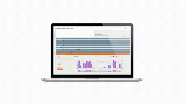
Satellite monitoring
specialized by crops

Analysis, graphs, and reports

Calendar with all available images
eupdated approximately every 5 days

Rankings for decision-making
Weather observation service
VISUAL’s website integrates weather observation service into all its solutions, providing relevant agroclimatic parameters with data accumulation since 2013, linking plots to the nearest public meteorological stations (AEMET).
Additionally, private or proprietary stations can be added to each organization upon request. This service is utilized for selecting the appropriate variety, planning sowings and plantations, and determining the expected harvest date.

Chill hours

Thermal accumulation

Rainfall

Sunlight hours
Evapotranspiration
What do VISUAL solutions have in common?
Agricultural remote sensing, VISUAL API connectivity, agroclimatic information… Regardless of the solution you choose, discover the common services to all VISUAL solutions.
VISUAL solutions are mobile
Have all the information at your fingertips, wherever you are. Visual App allows you to access and record all activities from any location, whether you have internet connection or not. When you regain connectivity, all the information you entered without connectivity will synchronize and be available in the cloud, for any device.
Do you want to know which VISUAL solution suits you best?
If you have any questions about a specific feature or if you’d like advice on which VISUAL solution best fits your needs, feel free to contact us.